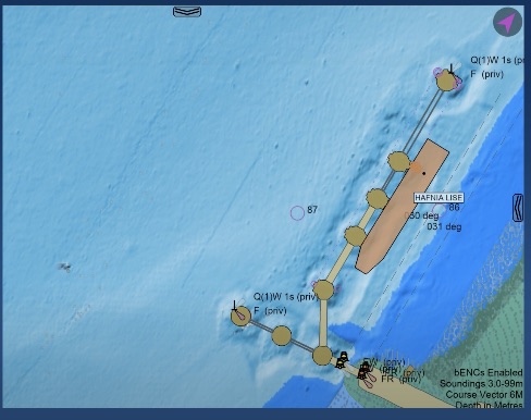

SEAiq Pilot in CSMART IHO S-100 Test Bed and Sea Trial Report
The report lists SEAiq Pilot among the ECS systems used and includes examples involving S-102, S-104, S-111, and S-129. Read about support for IHO S-100 series standards.
Notice: KSNTek WiFi Disconnect Issue
If you are using iOS 18 or later on your iPad/iPhone and experiencing periodic WiFi disconnects, please see these Instructions.
Notice: iPad/iPhone WiFi Issues
If you are using iOS 14 or later on your iPad/iPhone and experiencing problems connecting to WiFi devices, please see these Instructions.
SEAiq for Recreational Mariners
Recreational mariners can have many of the features in SEAiq Pilot, at a much lower price by using one of our recreational apps. The SEAiq apps display marine charts on your iPad and provide most common chart plotter features and leveraging the high quality displays and integrated GPS found on most iPads.
All our apps provide crisp and clear chart display (see our screen shots). All fonts and symbols are generated specifically for your device so they are clear and easy to read. When specified by the chart, SEAiq uses symbolized lines and area patterns, making the charts easier to ready and giving them a raster-like appearance (SEAiq apps are the only ones to do this).
Other features common to all our apps include:
- Fully offline use: there is no need to be connected to the internet
- Includes a base chart of the world (not suitable for navigation)
- View charts using normal iPad gestures, including pan, zoom, and rotate.
- Chart quilting: when viewing areas covered by different charts, SEAiq will quilt them together, selecting the best available chart data for the scale you are viewing at.
- Full access to all data in vector charts. You can select any point and access all the data associated with each of the features. Vector charts contain much more information than most mariners realize.
- GPS
- Integrated GPS available on most iPads and iPhones to indicate your current location, course, and speed.
- External NMEA to get GPS information (and other sensors) from your vessel (requires WiFi enabled NMEA).
- GPS sharing. You can access GPS information from another device. This is useful if you have a WiFi-only iPad without integrated GPS support. It can connect wirelessly to an iPhone or iPad with GPS.
- AIS. Display AIS targets on your chart display according to their reported location.
- Predicted course display including rate-of-turn information, when zoomed in sufficiently.
- Textual and visual CPA.
- True-scale vessel representation, accounting for location of the GPS antenna.
- Requires WiFi enabled AIS/NMEA.
- Tracks. See the route your vessel has followed.
- Waypoints and routes. Create and edit waypoints and routes directly from the chart display.
- Weather. Automatic and manual download of wind and pressure/isobar data.
- Customized display using Shallow, Safety, and Deep Depth Contours you provide. This allows the charts to highlight features that are possible danger.
- Day, evening, night color modes are available to help protect your night vision when in low light conditions.
- Display in variety of units. You can select the units you want displayed for depths, distances, speed, etc.
- True and magnetic north.
- Keep awake mode keeps your iPad display from going to sleep.
All our products share the same core vector chart engine and so they have a similar set of features and look-and-feel.
Some of the apps are free and require an in-app purchase in order to enable all the features. In these cases, you'll see some parts of the app colored magenta to indicate an in-app purchase is required to enable the feature.
All our products support both vector and raster charts.
We have 2 recreational apps: SEAiq and SEAiq USA. SEAiq USA only uses charts for USA and territorial waters downloaded from NOAA. SEAiq uses NOAA charts, as well as charts you provide and is intended for mariners who need charts outside the USA.
SEAiq (US$49.99, International & USA)
SEAiq is the only vector marine chartplotter app that allows you to use your own charts on your iPhone or iPad. It supports S-57, S-63, Inland ENC, and BSB/KAP formats. You can also purchase S-63/S-57 charts for anywhere in the world from the ChartWorld online store. Users of Admiralty (UKHO) and PRIMAR charts can use an automatic download/update feature. SEAiq also supports free download and update of charts for USA (same as SEAiq USA).
You install charts by downloading them directly to your iPad/iPhone or transferring them from other apps, such as email or DropBox. For large numbers of charts, you can connect your iPad/iPhone to your laptop and transfer charts using iTunes following simple instructions we provide.
SEAiq is a free app. Some features require an in-app purchase (a single purchase will upgrade all your iPads and iPhones). You can load your charts into the app and confirm they work before making any purchase.
SEAiq USA (US$24.99, USA Only)
These apps are for USA and territorial waters and use the excellent charts freely available from NOAA and the US Army Corps of Engineers.
It very easy to download vector charts from NOAA and US ACoE, and to keep them up to date. Charts are grouped into regions; you select one or more regions that you want charts for and the charts are automatically downloaded. Later you can update your charts by visiting the Charts tab to download a new catalog of the charts. The app then determines which charts have been updated and downloads just the updates. Of course, you can add or remove regions any time you want. It is that simple!
Because charts are downloaded directly from NOAA, chart updates are available as soon as NOAA publishes them. NOAA updates their charts daily and many weeks may update as many as 10% of all their charts, as well as publish new charts. It is importante to track those changes.