
SEAiq Pilot in CSMART IHO S-100 Test Bed and Sea Trial Report
The report lists SEAiq Pilot among the ECS systems used and includes examples involving S-102, S-104, S-111, and S-129. Read about support for IHO S-100 series standards.
Notice: KSNTek WiFi Disconnect Issue
If you are using iOS 18 or later on your iPad/iPhone and experiencing periodic WiFi disconnects, please see these Instructions.
Notice: iPad/iPhone WiFi Issues
If you are using iOS 14 or later on your iPad/iPhone and experiencing problems connecting to WiFi devices, please see these Instructions.
IHO S-100 Series Standards
SEAiq Pilot supports IHO S-100 standards, including S-101, S-102, S-104, S-111, and S-129. These require our Enterprise Subscription.
News
SEAiq Pilot Included in CSMART IHO S-100 Test Bed and Sea Trial Report
The report lists SEAiq Pilot among the ECS systems used and includes examples involving S-102, S-104, S-111, and S-129. Read the announcement.
S-101 Support Now Available
We are pleased to announce SEAiq Pilot supports S-101 Electronic Navigation Charts. The support is provided for evaluation purposes and we are requesting feedback on the new feature.
SEAiq Pilot Joins with UKHO and Shom in International S-100 Sea Trials
Throughout the trials, the UKHO and Shom will collect evidence to inform safety and efficiency use cases, while providing guidance on the introduction of the S-100 data framework, which is set to underpin the future of maritime navigation. These insights will play a key role in building global readiness and alignment on how S-100 data standards can be created and harmonised across international borders.
The programme will also bring together multiple ECDIS and portable pilot unit manufacturers, including Raymarine, Furuno, Navtor, OSI Maritime Systems, Seall ECDIS and SEAiq. This cross-industry collaboration will enable a detailed evaluation of the interoperability of S-100 data layers and help guide the development of next-generation S-100 display units.
During the trials, six interoperable S-100 data layers – Electronic Navigational Charts (S-101), bathymetric surface (S-102), water levels (S-104), surface currents (S-111), navigational warnings (S-124) and catalogue of nautical products (S-128) – will be used across multiple ECDIS units in live navigation scenarios.
Long Beach Pilots to Use S-102 Charts
After much testing and review, in July 2023, Jacobsen Pilots, in Long Beach California, announced that they have seamlessly transitioned to the new S-102 chart format! They stated, The S-102 charts bring a new level of accuracy to our portable electronic navigation units, increasing safety in a port where transits with minimal under keel clearances are common.
Steering the development of the S-102 Bathymetric Surface standard with the mariner in mind
The first, of a number of trials, is the S-102 project that we recently announced in collaboration with Port of London Authority (PLA) and SEAiq Pilot. This is the first real-world S-102 sea trial in the UK and also marks the first time the UKHO has run an S-100 sea trial. Working in collaboration with the PLA and SEAiq Pilot, the UKHO will test S-102 Bathymetric Surface product specifications in real-life scenarios with the PLA pilots to understand user requirements and collect their feedback. This feedback will help to influence the S-100 data standard development process, in turn improving product specifications, data coverage and the user experience.
Piloting with S-102 (Canada) Canadian Hydrographic Service S-102 Project
This video summarizes a project completed for the Canadian Hydrographic Service for S-102 High-Resolution Bathymetric charts in SEAiq Pilot. The participants included Maritime Simulation and Resources Center, Corporation dec Pilots du Bas Saint Laurent (Lower St Lawrence Seaway Pilots), and us. If you have S-102 charts for your area, you can contact us about enabling this support in SEAiq Pilot.
S-101 Electronic Navigation Charts
- Formats: version 2 and later
- Allows S-102 overlays
- Automatic Download from PRIMAR and manual installation
- Currently in Testing
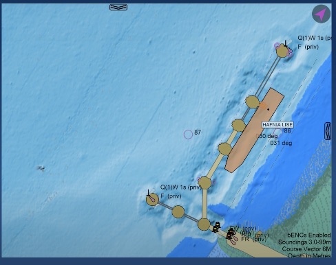
S-102 Bathymetric Surface
- Formats: version 2 and later
- Presentation: raster and vector
- Raster format supports hill-shading
- Allows overlay on ENC and S-102 data
- Touch-based probe of gridded data
- Options to select contours and intervals
- Automatic download/update of S-102 data for USA from NOAA
S-104 Water Level
- Formats: individual stations, gridded (regular and ungeorectified)
- Graphical display of current arrows
- Touch-based probe of gridded data
- Slider to select prediction times
S-111 Surface Currents
- Formats: individual stations, gridded (regular and ungeorectified)
- Graphical display of current arrows
- Touch-based probe of gridded data
- Slider to select prediction times
- Automatic download/update of S-111 cells for USA from NOAA
S-129 Dynamic Undekeel Clearance
- Formats: support for OMC S-129 cells
- Graphical display of S-129 overlay
- Automatic download of available plans
- Currently in Testing
Support is only included for data that conforms to official IHO standards.