
SEAiq Pilot in CSMART IHO S-100 Test Bed and Sea Trial Report
The report lists SEAiq Pilot among the ECS systems used and includes examples involving S-102, S-104, S-111, and S-129. Read about support for IHO S-100 series standards.
Notice: KSNTek WiFi Disconnect Issue
If you are using iOS 18 or later on your iPad/iPhone and experiencing periodic WiFi disconnects, please see these Instructions.
Notice: iPad/iPhone WiFi Issues
If you are using iOS 14 or later on your iPad/iPhone and experiencing problems connecting to WiFi devices, please see these Instructions.
Detailed Features
Datasheet
Download a datasheet for SEAiq Pilot
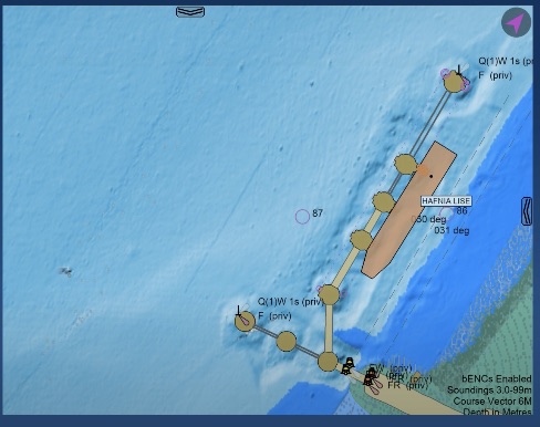
Charts
- Supported formats: S-101, S-102, S-57, S-63, iENC, Bathymetric ENC, Port ENC, BSB/KAP.
- Chart quilting: When viewing areas covered by multiple charts, SEAiq will quilt them together, selecting the best available chart data for the scale you are viewing at.
- Full access to all data in vector charts. You can select any point and access all the data associated with each of the features. Vector charts contain much more information than most mariners realize.
- Adheres to IHO S-52, S-57, S-63 and S-101 chart display standards.
- NOAA Charts: Automatic download/update for vector charts.
- US Army Corps of Engineers: automatic download/update for iENC vector charts.
- PRIMAR, ChartWorld, Admiralty, Datema, Nautitec, Australian Hydrographic Office, New Zealand: automatic download/update.
- Allows loading your own charts.
- Fully offline use: There is no need to be connected to the internet.
- Customized display using Shallow, Safety, and Deep Depth Contours you provide. This allows the charts to highlight features that are possible danger.
- Day, evening, night color modes are available to help protect your night vision when in low light conditions.
Chart Overlay (Requires Enterprise Subscription)
- Bathmetric ENC (bENC) Charts in a variet of formats
- XYZ
- ShapeFile
- Autocad DXF
- S-102
Pilot Logbook
- Maintain record of piloting work
- Automatically records time, position, course, vessel and nearby AIS targets
- Optionally add images: either screenshots or camera
- Print from iPad or export via email
Routes and Waypoints
- Unlimited waypoints and routes
- Create and edit waypoints and routes directly from the chart display.
- Cross-Track-Distance (XTD), including per-segment port/starboard, and alarm
- Optional Turning Radius
- Wheel-over Marks
- Speed Limits: Set maximum speeds and receive alarms
- Goal Times: Set time to reach waypoints
- Passing Restrictions: Indicate segments large vessels are restricted from passing
- Import/Export Formats: GPX, KML, RTU, RT3, RTZ, NACOS, SAM, CSV
AIS / NMEA
- Support for WiFi AIS pilot plugs and PPUs on all platforms
- Support for Bluetooth AIS pilot plugs and PPUs on Windows and MacOS
- AIS Network Feed: Connect to shore-based AIS feed.
- AIS Sharing: Worldwide AIS feed
- Virtual Boarding: Treat AIS target as Own-Ship
- Textual and visual Closest Point of Approach (CPA)
- Textual and visual Bow Crossing Range (BCR)
- True-scale vessel representation, accounting for location of the GNSS antenna
- AIS Environmental Messages (weather and tides)
Collision Avoidance
- Numerous alarms
- Optional spoken alarms (on Apple iOS)
- Route segments with passing restrctions can have alarms.
- New AIS target alarm
- New Meeting Point Alarm
- Closest Point of Approach (CPA)
- Bow Crossing Distance (BCD)
- Restricted Passing Alarm
- Trial ROT and SOG Selectors
Docking Aids
- Docking aids displaying distance/velocity to wharf for key points on vessel
- Graphical and textual Display
- Distances and speeds to fenders
- Automatic fender and wharf selection
- Angle to wharf
- Predicted vessel display (with ROT)
- Vessel motion analysis (speed ahead/astern, bow and stern speed to port/starboard)
- Single Point Mooring
- Vessel history shows recent motion of vessel.
Mariners Tools
- Variable Range Markers (VRM)
- Electronic Bearing Lines (EBL)
- Mariners Notes
- Tools can be attached to own-ship, AIS targets, and waypoints
- Mark lines, polygons with user selected color, line style
Record and Playback
- Automatically record all data from your AIS Pilot Plug.
- Playback and view all vessels in your recordings.
Tide and Current (Requires Enterprise Subscription)
- Official NOAA Tide and Currents download
- Official CHS Tide and Currents download
- Graphical interface with AyeTides app (iPad/iPhone)
- Unofficial Tide and Currents for USA and global
- IHO S-104 and S-111
Other Features
- Weather. Automatic and manual download of wind and pressure/isobar data
- Tracks: See the route your vessel has followed.
- Keep awake mode keeps your display from going to sleep.
- Under Keel Clearance calculator
Compatibility
- Apple iPads, iPad mini, iPhones with iOS 10 or later
- Apple MacOS: 64-bit, 10.11 or later
- Microsoft Windows: 64-bit x86, Windows 10 or later
- All external GNSS devices
- All WiFi AIS Pilot Plugs
- All Bluetooth Pilot Plugs on Windows and MacOS
- Pilots TECH WiFi based plugs
- Navicom Dynamics WiFi ChannelPilot and GyroPilot
- Marimatech CAT ROT and CAT I (may require Enterprise Subscription)
- All WiFi PPUs, including Navicom Dynamics and Marimatech
- Import/export using: email, DropBox, AirDrop, iTunes File Transfer
- Formats: GPX, KML, RTU, RT3, XML, HTML